Saturday, June 24
We all met at Durena's house at 5:00 a.m., drove to the airport in two vehicles and flew to Manchester, New Hampshire by way of Detroit. Picked up the rented minivan and drove to Pinkham Notch (about 125 miles, took about 3.5 hours). We stopped at a Subway for lunch and made a quick stop at a local grocery store for some apples, diet coke, doritos (guess who?), and a surprise birthday cake for Durena. We checked into AMC’s Joe Dodge Lodge in Pinkham Notch (elavation 2032 ft), obtained info at the Visitor Center, and checked out gear in the small store. Dinner was served family style and included freshly baked bread, salad, vegetables, chicken and dessert. We rolled back over to the lodge to finish organizing our packs for the week and we surprised Durena with the cake and a Life is Good shirt!
%20from%20jan%20joe%20dodge%20lodge%20group%20with%20durena%20for%20birthday%20(Small).1.jpg) Happy Birthday Durena!
Happy Birthday Durena!%20joe%20dodge%20lodge%20group%20off%20first%20day%20(Small).0.jpg)
First morning - ready to head out - look how clean we are!
Sunday, June 25
We got up about 6:30, dressed and walked over to the breakfast buffet at the visitors center. After we got the car packed, we caught the 8:45 AMC shuttle to the trailhead. It was a long ride (2+ hours), with several stops but we eventually arrived at the Old Bridle path trailhead (in Franconia Notch, elevation 1600 ft) and started walking up.
It was a relatively short trail to the hut, only 2.7 miles, we we gained 2450 feet and it took us about 3 hours. The weather was perfect, clear and not too hot, and we caught an occasional breeze. The views from the overlooks was amazing - mountain peaks as far as you could see!. We rounded a bend, and all of a sudden, there was the hut! It was a welcome sight. We went in and claimed our bunks. Mine was on the 3rd level and there is a cool shelf when I have all my stuff unpacked. I have to make some adjustments to my pack in the am - it was tall and skinny plus the top part was packed too full and it kept hitting me in the back of the head :)
Dinner was again served family style: soup, homemade bread, salad, stuffed shells, corn and 'congo bars' for dessert (choc chip and walnut). After dinner, people hung out in the dining room - reading, playing cards, games, talking, etc. Lights out at 9:30!
We got up about 6:30, dressed and walked over to the breakfast buffet at the visitors center. After we got the car packed, we caught the 8:45 AMC shuttle to the trailhead. It was a long ride (2+ hours), with several stops but we eventually arrived at the Old Bridle path trailhead (in Franconia Notch, elevation 1600 ft) and started walking up.
It was a relatively short trail to the hut, only 2.7 miles, we we gained 2450 feet and it took us about 3 hours. The weather was perfect, clear and not too hot, and we caught an occasional breeze. The views from the overlooks was amazing - mountain peaks as far as you could see!. We rounded a bend, and all of a sudden, there was the hut! It was a welcome sight. We went in and claimed our bunks. Mine was on the 3rd level and there is a cool shelf when I have all my stuff unpacked. I have to make some adjustments to my pack in the am - it was tall and skinny plus the top part was packed too full and it kept hitting me in the back of the head :)
Dinner was again served family style: soup, homemade bread, salad, stuffed shells, corn and 'congo bars' for dessert (choc chip and walnut). After dinner, people hung out in the dining room - reading, playing cards, games, talking, etc. Lights out at 9:30!
%20from%20pat%20front%20porch%20of%20greenleaf%20(Small).0.jpg)
Reading on the porch of Greanleaf Hut
Monday, June 26
Well, the hike today is 'advertised' as 7.7 miles, gaining an elevation of 2950 ft and taking around 6 hours. After a great breakfast served by the hut "Croo", we headed outside into pouring down rain when we left Greenleaf and the wind was really howling. When we were exposed on the face of Mt. Washington, the rain felt and sounded like sleet. It was a shame, because when it's clear, the niews are said to be spectacular, but all we could see was the got and clouds rolling by. There were two really long, steep climbs and the rest of the day was up and down continuously. We did some major climbing up and over huge rocks and ledges. I fell several times, mostly on the downs. The falls on the moss were funny, the falls on the rocks, not so much. We all took much longer than the posted time. Durena stayed even longer to make sure I made it in. It took us 10 hours and dinner was being served when we arrived - everyone applauded when we came in! Dinner and overnight here, Galehead Hut (elevation 3800 ft).
Well, the hike today is 'advertised' as 7.7 miles, gaining an elevation of 2950 ft and taking around 6 hours. After a great breakfast served by the hut "Croo", we headed outside into pouring down rain when we left Greenleaf and the wind was really howling. When we were exposed on the face of Mt. Washington, the rain felt and sounded like sleet. It was a shame, because when it's clear, the niews are said to be spectacular, but all we could see was the got and clouds rolling by. There were two really long, steep climbs and the rest of the day was up and down continuously. We did some major climbing up and over huge rocks and ledges. I fell several times, mostly on the downs. The falls on the moss were funny, the falls on the rocks, not so much. We all took much longer than the posted time. Durena stayed even longer to make sure I made it in. It took us 10 hours and dinner was being served when we arrived - everyone applauded when we came in! Dinner and overnight here, Galehead Hut (elevation 3800 ft).
%20from%20heidi%20Valerie-Jan-and-Durena%20(Small).jpg)
Rained most of the second day - hike took 10-11 hours - big steps up and down ALL DAY!!
Tuesday, June 27
After breakfast we headed out into rain again and began our 7 mile hike to Zealand Falls Hut (elevation 2700 ft.) via the A.T. (also called the Twinway Trail). Elevation gain is 1750 ft, there was a very steep climb to the summit of South Twin and then it was mostly downhill.It took us about 8 hours. The weather cleared up, the sun came out and we were treated to some very pretty views! The Zealand Hut is right next to Zealand Falls and after we dropped our packs, got boots off and clothes changed, we walked over a few rocks to the falls and stuck our feet in. Spent a pleasant afternoon lounging at the falls. Dinner tonight was vegetable lasagne, soup, salad, fresh bread and peanut butter bars.
%20from%20durena%20bunkbeds%20at%20zealand%20falls%20hut%20(Small).jpg)
Typical bunk room at the huts
%20from%20heidi%20leaving%20galehead%20hut%20pat%20valerie%20jan%20durena%20(Small).jpg)
On the porch of Galehead Hut the next morning - still damp, windy, cold!!
%20from%20durena%20zealand%20falls%20(Small).jpg)
Zealand Falls
Wednesday, June 28
Galehead Hut to Mizpah Hut, 8.1 miles
We split into two groups today. Jan's feet were bothering her yesterday and this morning she decided she'd had enough. Durena and I walked down a different trail with Jan and the Naturalist, who then drove us 3 miles to the Highland Lodge (train depot) where Jan caught a shuttle back to Pinkham Lodge. She is going to get to the van and then go and visit her son in Vermont. We were sad to see her go, but once your feet get torn up, hiking is no fun :(
Durena and I walked up the trail toward Mizpah Hut (elevation 3800ft) and made it under the estimated time for the first distance since we started! We got in about 2:00 and bought bowls of chicken/rice soup. It had rained the entire hike and we were freezing, so it was especially good :) Pat and Heidi arrived just after 3:00 and after they changed and dried off, we all sat at a table and swapped stories. Pat got the coffee supplies out and she and I each made a cup of the 'good stuff'. It was the first time we got in early enough to sit and relax before dinner :)
The rest of the group making the same hike started trickling in and soon we were all discussing the day. Later we noticed a boy wearing an IU sweatshirt and found out he will be a junior there next year. His name was Joe McGibbon and he was studying non-profit and religious studies. We retired to our bunks and Pat demonstrated the flashing light feature of her new headlamp :)
Galehead Hut to Mizpah Hut, 8.1 miles
We split into two groups today. Jan's feet were bothering her yesterday and this morning she decided she'd had enough. Durena and I walked down a different trail with Jan and the Naturalist, who then drove us 3 miles to the Highland Lodge (train depot) where Jan caught a shuttle back to Pinkham Lodge. She is going to get to the van and then go and visit her son in Vermont. We were sad to see her go, but once your feet get torn up, hiking is no fun :(
Durena and I walked up the trail toward Mizpah Hut (elevation 3800ft) and made it under the estimated time for the first distance since we started! We got in about 2:00 and bought bowls of chicken/rice soup. It had rained the entire hike and we were freezing, so it was especially good :) Pat and Heidi arrived just after 3:00 and after they changed and dried off, we all sat at a table and swapped stories. Pat got the coffee supplies out and she and I each made a cup of the 'good stuff'. It was the first time we got in early enough to sit and relax before dinner :)
The rest of the group making the same hike started trickling in and soon we were all discussing the day. Later we noticed a boy wearing an IU sweatshirt and found out he will be a junior there next year. His name was Joe McGibbon and he was studying non-profit and religious studies. We retired to our bunks and Pat demonstrated the flashing light feature of her new headlamp :)
%20from%20jan%20zealand%20falls%20view%20from%20front%20porch%20at%20sunrise%20(Small).jpg)
View from porch of Zealand Falls Huts
%20sign%20to%20z%20falls%20hut%20jan%20valerie%20durena%20(Small).jpg)
Group split into two groups - two different routes - met back up later at Mizpah Hut
Thursday, June 29
Mizpah Hut to Lake of the Clouds Hut, 4.8 miles (1650 ft elevation gain)
 View hiking to Lake of the Clouds Hut
We really enjoyed the 'bird skit' this morning at breakfast at Mizpah :) We had a beautiful hike today along the A.T. in the Presidentials to Lake of the Clouds Hut (elevation 5050 ft, largest and highest hut).We got in early enough to snag 4 low bunks and set about managing our gear. Pat, Durena and Heidi left after about 1/2 an hour to hike to the summit of Mt. Washington. I got cleaned up, took a short nap, sat out in the sun, found a sunny spot for my boots, read my book and just hung out. After a couple of hours I sat in the dining room and talked to Linda. She, Pat and Michael had started the hike up to Mt.Washington when they met Caroline, who was headed down and told them there was a storm on the way. While we were talking, it got cloudy and dark and soon it started raining. Durena, Pat and Heidi came in about 10 minutes after that and they were soaked! After they got changed and came and sat down, we watched and waited for Don, Olivia, Alexandra (and John) to appear. It was another half hour before they appeared, they had to take shelter from the hail on the descent!
 Summit of Mt. Washington
There was a big group of us doing the same itinerary on the Hut-to-Hut walk. We took a group picture before dinner and they let us reserve a table and a half so we could sit together. During the day we play leap frog as we pass each other on the trail.

Mizpah Hut to Lake of the Clouds Hut, 4.8 miles (1650 ft elevation gain)
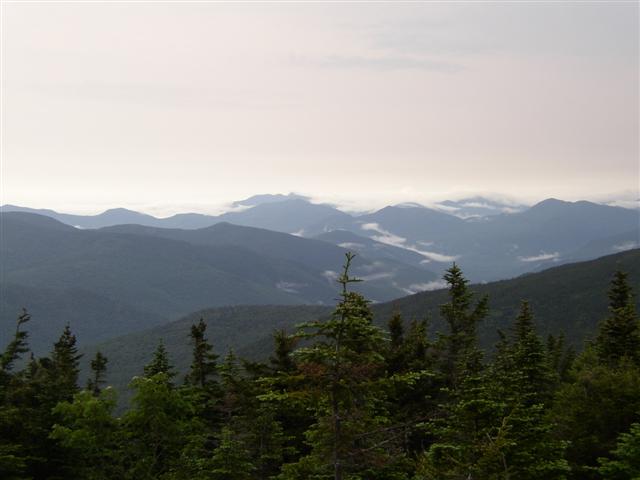 View hiking to Lake of the Clouds Hut
We really enjoyed the 'bird skit' this morning at breakfast at Mizpah :) We had a beautiful hike today along the A.T. in the Presidentials to Lake of the Clouds Hut (elevation 5050 ft, largest and highest hut).We got in early enough to snag 4 low bunks and set about managing our gear. Pat, Durena and Heidi left after about 1/2 an hour to hike to the summit of Mt. Washington. I got cleaned up, took a short nap, sat out in the sun, found a sunny spot for my boots, read my book and just hung out. After a couple of hours I sat in the dining room and talked to Linda. She, Pat and Michael had started the hike up to Mt.Washington when they met Caroline, who was headed down and told them there was a storm on the way. While we were talking, it got cloudy and dark and soon it started raining. Durena, Pat and Heidi came in about 10 minutes after that and they were soaked! After they got changed and came and sat down, we watched and waited for Don, Olivia, Alexandra (and John) to appear. It was another half hour before they appeared, they had to take shelter from the hail on the descent!
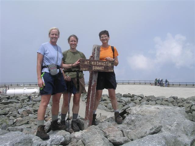 Summit of Mt. Washington
There was a big group of us doing the same itinerary on the Hut-to-Hut walk. We took a group picture before dinner and they let us reserve a table and a half so we could sit together. During the day we play leap frog as we pass each other on the trail.

Group we traveled along with - leapfrogging along the way - hung out in the evenings and "talked trail"
John and his dad and uncle
John and his dad and uncle
Linda, Pat and Michael
Chris and Sarah (own bookstore)
Don, Olivia and Alexandra
Caroline
Us! Pat, Durena, Heidi, me :)
Friday, June 30
Lake of the Clouds to Madison, 7.5 miles
After another great breakfast, we set off on our hike to Madison Hut. We made good time for the first half of the day - the weather was crisp and sunny - but as the day went on the clouds moved in and soon the landscape was alien. We were above treeline so all we could see was the mist swirling about, the silhouette of the person in front of you and the outlines of the rock cairns. We still had to go up and over Mt. Adams and as we started our ascent the wind really picked up and the rain came harder and then we heard a rumble of thunder! We took a brief break hunkered behind a big rock but we were still getting pummeled and looked for better shelter. We found a huge boulder with an overhang and headed toward it. We got our fleeces out and put them on under our raincoats. We stayed put for about a half an hour.
%20from%20heidi%20fog,%20signs,%20rocks%20(Small).jpg)
This view after we passed a sign that said we were entering an area that had the "worst weather in the world" Signposts looked like crosses - I said my prayers!
%20gulfside%20trail%20from%20heidi%20taking%20shelter%20durena%20pat%20heidi%20(Small).0.jpg)
Had to take shelter from a sudden storm and stay put for a while (lots of thunder and lightning)
Saturday, July 1
Madison Hut to Pinkham Notch, 7.7 miles
We had a pleasant walk this morning on our last hiking day. We spent the day descending about 3500 feet. It tooks us about 5 hours and we spent the night back at the Joe Dodge Lodge!
Madison Hut to Pinkham Notch, 7.7 miles
We had a pleasant walk this morning on our last hiking day. We spent the day descending about 3500 feet. It tooks us about 5 hours and we spent the night back at the Joe Dodge Lodge!

View leaving Madison Hut
Sunday, July 2
Drove to Manchester and flew back to Indy.
http://www.outdoors.org/lodging/huts/index.cfm
Drove to Manchester and flew back to Indy.
http://www.outdoors.org/lodging/huts/index.cfm


